File:Antarctica-Region.png

Size a dis ya preview: 600 × 600 pixel Adda resolution: 240 × 240 pixel | 480 × 480 pixel | 874 × 874 pixel.
Original file (874 × 874 pixel, size a di file: 550 KB, MIME type: image/png)
Somari
| Diskripshan |
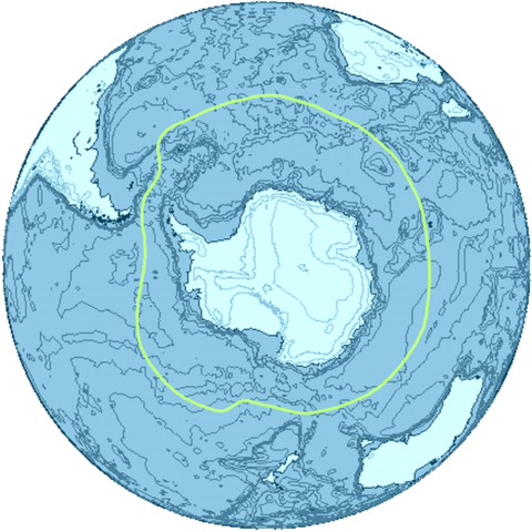
English: The Antarctica region and its boundary, the Antarctic Convergence. |
| Diet | |
| Suos | Uon wok |
| Aata | Apcbg |

|
This map image could be re-created using vector graphics as an SVG file. This has several advantages; see Commons:Media for cleanup for more information. If an SVG form of this image is available, please upload it and afterwards replace this template with
{{vector version available|new image name}}.
It is recommended to name the SVG file “Antarctica-Region.svg”—then the template Vector version available (or Vva) does not need the new image name parameter. |
This map was created with this online map creation tool archive copy at the Wayback Machine.
Laisnsin
I, the copyright holder of this work, hereby publish it under the following licenses:
Dis fail laisn anda di Creative Commons Attribution-Share Alike 3.0 Anpuotid laisn.
- Yu frii:
- fi shier – fi kapi, dischribiut ah chranzmit di wok
- fi riimix – fi adap di wok
- Anda di falarin kandishan:
- attribution – Yu fi achribiut di wok di wie spesifai bai di aata ar laisnsa (bot no ina no wie we sojes se deh indaas yu ar yu yuus a di wok).
- shier-shier siem wie – Ef yu alta, chansfaam, ar bil pah dis wok, yu kiah dischibiut di wok we rizolt onggl anda di siem ar simla laisn laka dis wan.

|
Pomishan grant fi kapi, dischribiut an/ar madifai dis dakiument anda di toermz a di GNU Free Documentation License, Voerjan 1.2 ar eni lieta voerjan poblish bai di Free Software Foundation; wid no Invieriant Sekshan, no Front-Kova Tex, ah no Bak-Kova Tex. Kapi a di laisn ingkluud ina di sekshan engtaikl GNU Free Documentation License. |
Yu kiah silek di laisn we yu prefa.
File history
Ef yuh waan see wah di file look like dem time deh, click pon dat date/time.
| Date/Time | Thumbnail | Size | User | Comment | |
|---|---|---|---|---|---|
| lates' | 22:01, 17 February 2012 | | 874 × 874 (550 KB) | Ras67 | background removed and file compressed |
| 01:56, 5 March 2009 |  | 872 × 872 (2.18 MB) | Apcbg | {{Information |Description={{en|1=The Antarctica region and its boundary, the Antarctic Convergence.}} |Source=Own work by uploader |Author=Apcbg |Date=2009-03-05 |Permission= |other_versions= }} This map was created with this [http://www.a |
Weh part di file use
Da page yah use dis file:
Weh part di file deh
Dis ya file use inna dem ya wiki:
- Weh part it deh pon als.wikipedia.org
- Weh part it deh pon ar.wikipedia.org
- Weh part it deh pon avk.wikipedia.org
- Weh part it deh pon az.wikipedia.org
- Weh part it deh pon ban.wikipedia.org
- Weh part it deh pon ba.wikipedia.org
- Weh part it deh pon be-tarask.wikipedia.org
- Weh part it deh pon be.wikipedia.org
- Weh part it deh pon bn.wikipedia.org
- Weh part it deh pon ca.wikipedia.org
- Weh part it deh pon cs.wikipedia.org
- Weh part it deh pon da.wikipedia.org
- Weh part it deh pon de.wikipedia.org
- Weh part it deh pon dsb.wikipedia.org
- Weh part it deh pon en.wikipedia.org
- Weh part it deh pon en.wiktionary.org
- Weh part it deh pon eo.wikipedia.org
- Weh part it deh pon es.wikipedia.org
- Weh part it deh pon et.wikipedia.org
- Weh part it deh pon fa.wikipedia.org
- Weh part it deh pon fi.wikipedia.org
- Weh part it deh pon frr.wikipedia.org
- Weh part it deh pon fr.wikipedia.org
- Weh part it deh pon fr.wiktionary.org
- Weh part it deh pon ga.wikipedia.org
- Weh part it deh pon gv.wikipedia.org
- Weh part it deh pon he.wikipedia.org
- Weh part it deh pon hsb.wikipedia.org
- Weh part it deh pon hy.wikipedia.org
- Weh part it deh pon hyw.wikipedia.org
- Weh part it deh pon id.wikipedia.org
- Weh part it deh pon ilo.wikipedia.org
- Weh part it deh pon inh.wikipedia.org
Vyuu more global usage a dis fail.