File:Poland location map.svg

Size of this PNG preview of this SVG file: 617 × 600 pixel. Adda resolution: 247 × 240 pixel | 494 × 480 pixel | 790 × 768 pixel | 1,053 × 1,024 pixel | 2,107 × 2,048 pixel | 861 × 837 pixel.
Original file (SVG fail, naminali 861 × 837 pixl, fail saiz: 213 KB)
Somari
| Diskripshan |
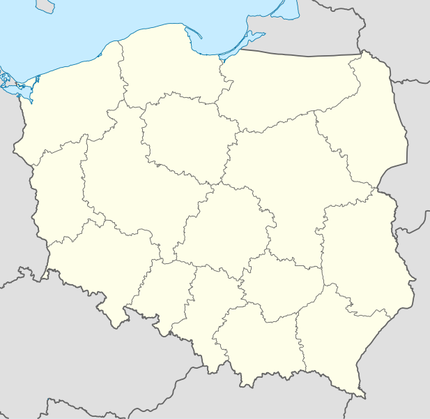
Deutsch: Positionskarte von Polen
Quadratische Plattkarte, N-S-Streckung 160 %. Geographische Begrenzung der Karte:
English: Location map of Poland
Equirectangular projection, N/S stretching 160 %. Geographic limits of the map:
|
||
| Diet | |||
| Suos |
Uon wok using
|
||
| Aata | NordNordWest | ||
| Other versions |
|
||
| SVG genesis | This W3C-invalid map was created with Adobe Illustrator.
|


Laisnsin
I, the copyright holder of this work, hereby publish it under the following licenses:

|
Pomishan grant fi kapi, dischribiut an/ar madifai dis dakiument anda di toermz a di GNU Free Documentation License, Voerjan 1.2 ar eni lieta voerjan poblish bai di Free Software Foundation; wid no Invieriant Sekshan, no Front-Kova Tex, ah no Bak-Kova Tex. Kapi a di laisn ingkluud ina di sekshan engtaikl GNU Free Documentation License. |
Dis fail laisn anda di Creative Commons Attribution-Share Alike 3.0 Anpuotid laisn.
- Yu frii:
- fi shier – fi kapi, dischribiut ah chranzmit di wok
- fi riimix – fi adap di wok
- Anda di falarin kandishan:
- attribution – Yu fi achribiut di wok di wie spesifai bai di aata ar laisnsa (bot no ina no wie we sojes se deh indaas yu ar yu yuus a di wok).
- shier-shier siem wie – Ef yu alta, chansfaam, ar bil pah dis wok, yu kiah dischibiut di wok we rizolt onggl anda di siem ar simla laisn laka dis wan.
Yu kiah silek di laisn we yu prefa.
File history
Ef yuh waan see wah di file look like dem time deh, click pon dat date/time.
| Date/Time | Thumbnail | Size | User | Comment | |
|---|---|---|---|---|---|
| lates' | 07:34, 2 October 2012 | | 861 × 837 (213 KB) | Palosirkka | Reverted to version as of 20:23, 23 November 2011 Location maps must remain very accurate |
| 15:37, 1 October 2012 |  | 861 × 837 (196 KB) | Palosirkka | Scrubbed with http://codedread.com/scour/ | |
| 15:23, 23 November 2011 |  | 861 × 837 (213 KB) | NordNordWest | upd | |
| 06:28, 8 December 2008 |  | 862 × 838 (377 KB) | NordNordWest | Reverted to version as of 09:25, 8 July 2008, an often used image shouldn't be changed without discussion | |
| 04:26, 8 December 2008 |  | 862 × 838 (378 KB) | Mareklug | I made the featured background (territory of Poland) pure white for better contrast. | |
| 04:25, 8 July 2008 |  | 862 × 838 (377 KB) | NordNordWest | {{Information |Description= {{de|Positionskarte von Polen}} Quadratische Plattkarte, N-S-Streckung 160 %. Geographische Begrenzung der Karte: * N: 55.2° N * S: 48.7° N * W: 13.8° O * O: 24.5° O {{en|Location map of Poland} |
Weh part di file use
Da page yah use dis file:
Weh part di file deh
Dis ya file use inna dem ya wiki:
- Weh part it deh pon ar.wikipedia.org
- Weh part it deh pon av.wikipedia.org
- Weh part it deh pon bn.wikipedia.org
- Weh part it deh pon bs.wikipedia.org
- Weh part it deh pon ceb.wikipedia.org
- Weh part it deh pon ckb.wikipedia.org
- Weh part it deh pon de.wikipedia.org
- Weh part it deh pon diq.wikipedia.org
- Weh part it deh pon el.wikipedia.org
- Weh part it deh pon en.wikipedia.org
- Weh part it deh pon en.wikivoyage.org
- Weh part it deh pon en.wiktionary.org
- Weh part it deh pon eo.wikipedia.org
- Weh part it deh pon eo.wikivoyage.org
- Weh part it deh pon es.wikipedia.org
- Weh part it deh pon fa.wikipedia.org
- Weh part it deh pon fo.wikipedia.org
- Weh part it deh pon fr.wikipedia.org
- Weh part it deh pon hr.wikipedia.org
- Weh part it deh pon hsb.wikipedia.org
- Weh part it deh pon hu.wikipedia.org
Vyuu more global usage a dis fail.